Property Record
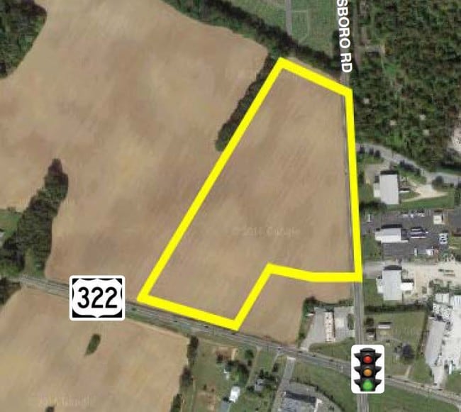
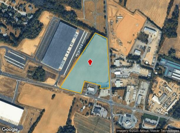
2021 Route 322, Swedesboro, NJ 08085
NEARBY LISTINGS FOR SALE OR LEASE
Property Detail
2021 Route 322
Philadelphia-Camden-Wilmington, PA-NJ-DE-MD
Minor Subdivision Plan Tax Lot 2 01 Bloc
24-00012-0000-00002-0000-QFARM
Gloucester
Farms
New Jersey
X
2
34015C0068F
15.69 AC
2024
Gloucester County
2025
Philadelphia
502201
DEMOGRAPHICS near 2021 Route 322
1 Mile
3 Mile
5 Mile
2024 Total Population
1,680
19,920
40,903
2029 Population
1,738
20,692
42,388
Pop Growth 2024-2029
+ 3.45%
+ 3.88%
+ 3.63%
Average Age
37
38
39
2024 Total Households
562
6,643
13,915
HH Growth 2024-2029
+ 3.38%
+ 4.09%
+ 3.78%
Median Household Inc
$90,624
$129,748
$123,317
Avg Household Size
3.00
3.00
2.90
2024 Avg HH Vehicles
2.00
2.00
2.00
Median Home Value
$296,666
$346,636
$345,972
Median Year Built
1975
2000
1994
Nearby Places
Map Layers
Map Styles
 Street
 Aerial
- Restaurants
- Banks
- Shops
- Fitness
- Groceries
PUBLIC TRANSPORTATION
COMMUTER RAIL
Highland Avenue (R2 - Southeastern Pennsylvania Transportation Authority Regional Rail (SEPTA Regional Rail))
DRIVE
WALK
Distance
Highland Avenue (R2 - Southeastern Pennsylvania Transportation Authority Regional Rail (SEPTA Regional Rail))
15 min
8.3 mi
Chester Transportation Center (R2 - SEPTA, Wilmington/Newark Line - SEPTA)
DRIVE
WALK
Distance
Chester Transportation Center (R2 - SEPTA, Wilmington/Newark Line - SEPTA)
17 min
9.7 mi
AIRPORT
Philadelphia International
DRIVE
WALK
Distance
Philadelphia International
27 min
16.1 mi
Freight Ports
Port of Wilmington, RI
DRIVE
WALK
Distance
Port of Wilmington, RI
31 min
19.9 mi
SALE & LEASE HISTORY
LISTING DATE
SALE/LEASE

Sep 24, 2016
For Sale
Dec 09, 2016
For Sale
Nearby Properties
Address
Land Use
TOTAL SIZE
Lot Size
Zoning
Address
Land Use
TOTAL SIZE
Lot Size
Zoning
11,013 SF
209.88 AC
RCC
Address
Land Use
TOTAL SIZE
Lot Size
Zoning
66.85 AC
R5
Address
Land Use
TOTAL SIZE
Lot Size
Zoning
27.69 AC
RCC
Address
Land Use
TOTAL SIZE
Lot Size
Zoning
Address
Land Use
TOTAL SIZE
Lot Size
Zoning
Address
Land Use
TOTAL SIZE
Lot Size
Zoning
13.94 AC
RCC
Address
Land Use
TOTAL SIZE
Lot Size
Zoning
28 AC
IC
Address
Land Use
TOTAL SIZE
Lot Size
Zoning
20.24 AC
RCC
Address
Land Use
TOTAL SIZE
Lot Size
Zoning
4,701 SF
48.76 AC
LI
Address
Land Use
TOTAL SIZE
Lot Size
Zoning
40.18 AC
Address
Land Use
TOTAL SIZE
Lot Size
Zoning
3,024 SF
25.03 AC
Address
Land Use
TOTAL SIZE
Lot Size
Zoning
2,784 SF
15.36 AC
LI
Address
Land Use
TOTAL SIZE
Lot Size
Zoning
20.19 AC
Address
Land Use
TOTAL SIZE
Lot Size
Zoning
Address
Land Use
TOTAL SIZE
Lot Size
Zoning
Address
Land Use
TOTAL SIZE
Lot Size
Zoning
2,106 SF
18.79 AC
Address
Land Use
TOTAL SIZE
Lot Size
Zoning
1,245 SF
23.43 AC
LI
Address
Land Use
TOTAL SIZE
Lot Size
Zoning
66.07 AC
Address
Land Use
TOTAL SIZE
Lot Size
Zoning
27.83 AC
VRC
Address
Land Use
TOTAL SIZE
Lot Size
Zoning
34.42 AC
Address
Land Use
TOTAL SIZE
Lot Size
Zoning
1,908 SF
9.44 AC
LI
Address
Land Use
TOTAL SIZE
Lot Size
Zoning
1,642 SF
16.72 AC
LI
Address
Land Use
TOTAL SIZE
Lot Size
Zoning
Address
Land Use
TOTAL SIZE
Lot Size
Zoning
10.13 AC
Address
Land Use
TOTAL SIZE
Lot Size
Zoning
1,250 SF
11.57 AC
IC
Address
Land Use
TOTAL SIZE
Lot Size
Zoning
46 AC
RC
Address
Land Use
TOTAL SIZE
Lot Size
Zoning
11.80 AC
Address
Land Use
TOTAL SIZE
Lot Size
Zoning
Address
Land Use
TOTAL SIZE
Lot Size
Zoning
10.16 AC
Address
Land Use
TOTAL SIZE
Lot Size
Zoning
1,196 SF
12.68 AC
LI
The World's #1 Commercial Real Estate Marketplace
Connect with us
© 2025 CoStar Group
The information above has been obtained from sources believed reliable. While we do not doubt its accuracy we have not verified it and make no guarantee, warranty or representation about it. It is your responsibility to independently confirm its accuracy and completeness. Any projections, opinions, assumptions, or estimates used are for example only and do not represent the current or future performance of the property. The value of this transaction to you depends on tax and other factors which should be evaluated by your tax, financial, and legal advisors. You and your advisors should conduct a careful, independent investigation of the property to determine to your satisfaction the suitability of the property for your needs.